KOTH - Southwest Oregon Regional
Located in North Bend, OR, USA
ICAO - KOTH, IATA - OTH, FAA ID - OTH
Airport Type
Civil
Lat/Long
N43-25.0/W124-14.8
Elevation (ft)
17
Fuel Available
AVGAS JET
Current UTC
12:57:25 AM (-8.00)
Approaches
ILS LOC GPS
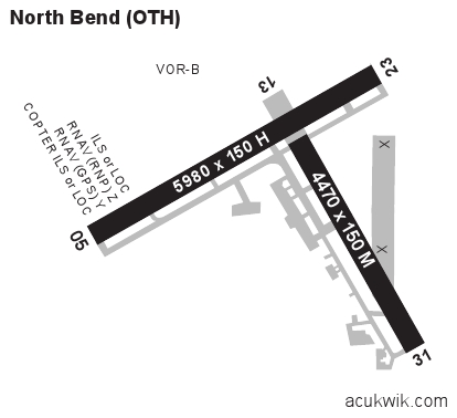
Longest Primary Runway (ft)
5980 x 150, 05/23
Runway Surface
Asphalt/Grooved
PCN
Local Standard Time
5:57:25 PM
More Airport Information (Click to expand)
Airport Light Intensity
HIGH
US Customs Pre-Clearance
No
DST
2nd Sun in Mar 0200L to 1st Sun in Nov 0200L
Control Tower Hours
0200-2200L
Distance from City
1 MILE NW OF CITY
Runway Diagram
FAA Diagram

Google Satellite Map of KOTH
Airport Distance Calculator
The distance from to is
Nautical Miles
Airport Restrictions and Information
Hotels
Quality Inn & Suites Coos Bay
Mill Casino-Hotel North Bend