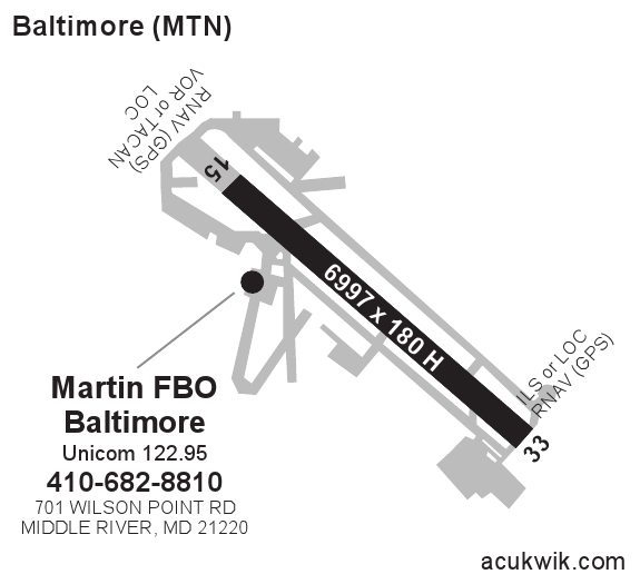
KMTN - Martin State Airport Information

Located in Baltimore, MD United States : ICAO - KMTN, IATA - MTN, FAA ID - MTN
Current UTC: 12:52:51 AM Lat/Long: N39-19.5/W076-24.8
Local Standard Time: 7:52:51 PM Airport Light Intensity: HIGH
Fuel Available: AVGAS JET Variation: 11W
Elevation (ft): 21 Approaches: ILS LOC GPS
Max. hard surfaced runway (ft): 6996 x 180 Open 24 Hours: Yes
PCN: Airport of Entry: No
AFTN: SITA:
Control Tower Phone: 410-682-8811 Slots Required: No
Airport Email: Control Tower Hours: 6A-10P
Sunrise: 6:06 AM Airport Website:
Sunset: 6:19 PM Handling Mandatory: No
Airport Information Frequency Phone Fax
WT & NOISE RESTRICT 410-682-8800
9 MILES E OF CITY
AWOS 3 124.925 410-682-8848

METAR: KMTN 212345Z 15014KT 10 SM BKN110 17/10 A2999=
TAF: LATEST TAF REPORT FOR KMTN KMTN 212347Z 2200/2224 14009KT P6SM BKN110 FM220800 14004KT P6SM VCSH SCT025 BKN040 OVC070 FM221100 11004KT 5SM -RA BR SCT008 BKN015 OVC025 FM221300 10006KT 2SM -RA BR OVC007 FM221700 11007KT 4SM -RA BR BKN009 OVC012 FM222200 12009KT 5SM -RA BR SCT008 OVC012= LATEST FC REPORT FOR KMTN *** NO MESSAGES FOUND ***
Temperature (F): 63 Weather:
Dewpoint: 50 Sky: Broken Clouds
Relative Humidity: 63 Ceiling: 11000
Wind Speed: 16 Visibility: 10
Wind Direction: 150°, SSE Heat Index: 63
Gust: Wind Chill: 63
Pressure: 29.99 Last Update: 2010-3-22T0:00:00 GMT
Complete Weather Including 7 Day Forecast
FREE FLIGHT TRACKING:
AC-U-KWIK now offers FREE Flight Tracking for any airport in the United States or Canada. To see aircraft information, hover over an aircraft on the map or click "Full Screen & Flight Details."

SUBSCRIPTION FLIGHT TRACKING & DETAILED GA ACTIVITY REPORTS:
For companies needing ongoing, detailed analysis of aircraft leaving or arriving at one or multiple airports OR for companies interested in gaining more market share at an airport by having access to detailed general aviation activity reports (including aircraft ownership information), then click here for more details.

MARTIN STATE AIRPORT
Phone:410-682-8810
Fax:410-682-8842
www.martinstateairport.com
Fuel: Phillips 66
Frequency: 122.95
Fuel Prices Self Full
JetA $0.00 $4.79
100LL $4.34 $4.54
Last Updated: 3/11/2010 6:11:39 AM
Name Price Range Distance  
Super 8 Baltimore Essex Area   more info... $67.15 - $91.99 28.55 mi  
Best Western Htl Conference   more info... $99.00 - $209.99 30.55 mi  
La Quinta Inn & Suites Baltimore North   more info... $49.00 - $95.00 30.58 mi  
RODEWAY INN BALTIMORE   more info... $53.99 - $69.99 30.61 mi  
Hilton Garden Inn White Marsh   more info... $127.00 - $199.00 30.90 mi  
HAMPTON INN BALTIMORE WHITE MAR   more info... $125.10 - $139.00 30.94 mi  
Residence Inn by Marriott Baltimore White Marsh   more info... $149.00 - $174.00 31.00 mi  
Americas Best Inn - Baltimore   more info... $67.00 - $71.00 31.42 mi  
BRIDGESTREET LIGHTHOUSE LANDING   more info... $199.00 - $209.00 31.69 mi  
BRIDGESTREET LANCASTER SQUARE   more info... $189.00 - $190.00 32.29 mi  
VOR
Vor: WESTMINSTER
Ident: EMI
Radial: 119.4
Distance from closest H VOR with a DME: 28.1
Coordinates: W076-58.7/N39-29.7
DME: DME
State: MD
Frequency: 117.9
Variation: 08W
Controlling FSS: LEESBURG
Discrete Frequencies: 122.2 122.6
Type VOR: HIGH
Controlling Center: NEW YORK CTR
ARTCC Sector Frequencies: 133.47H/132.2L
 
Vor: PHILLIPS
Ident: PPM
Radial: 242
Distance from closest VOR with a DME: 14.1
Coordinates: W076-10.3/N39-28.0
DME: 
State: MD
Frequency: 108.4
Variation: 09W
Controlling FSS: LEESBURG
Discrete Frequencies: 122.2 122.6
Type VOR: TERM
Controlling Center: WASHINGTON CTR
ARTCC Sector Frequencies: 135.52H/135.4L
KMTN Services Summary
VOR


Version: 5.4.5rc4_B